UFZ Spatial Data Catalogue
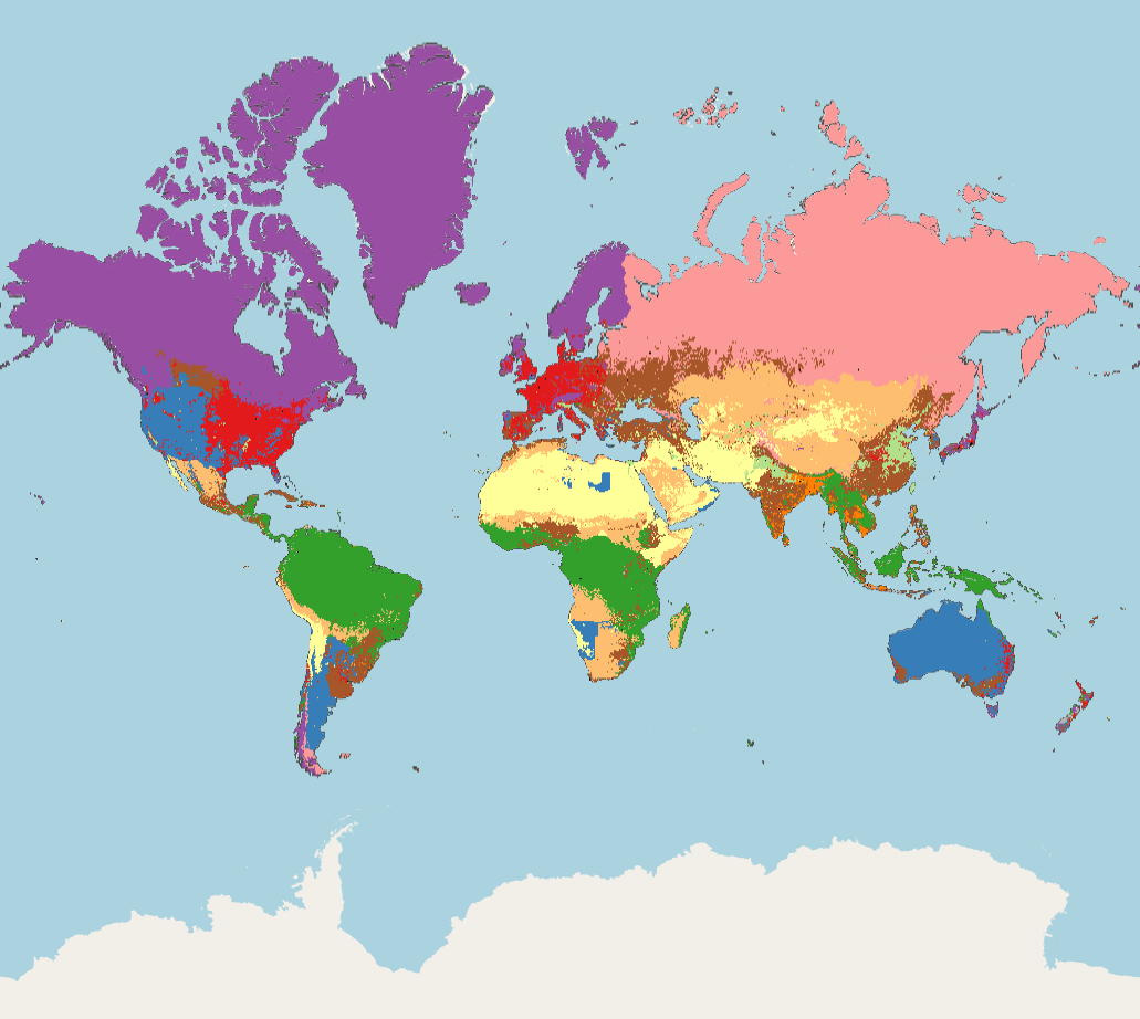
Land system archetypes (WMS)
This service visualizes land system archetypes data. Land use is a key driver of global environmental change. Unless major shifts in consumptive behaviours occur, land-based production will have to increase drastically to meet future demands for food and other commodities. To better understand the drivers and impacts of agricultural intensification, identifying global, archetypical patterns of land systems is needed. However, current approaches focus on broad-scale representations of dominant land cover with limited consideration of land-use intensity. In this study, we derived a new global representation of land systems based on more than 30 high-resolution datasets on land-use intensity, environmental conditions and socioeconomic indicators. Using a self-organizing map algorithm, we identified and mapped twelve archetypes of land systems for the year 2005. Our analysis reveals unexpected similarities in land systems across the globe but the diverse pattern at sub-national scales implies that there are no one-size-fits-all solutions to sustainable land management. Our results help to identify generic patterns of land pressures and environmental threats and provide means to target regionalized strategies to cope with the challenges of global change. Mapping global archetypes of land systems represents a first step towards better understanding the driving forces and environmental and social outcomes of land system dynamics.
Simple
- Date (Creation)
- 2013-02-07
- Citation identifier
- glues:ufz:metadata:service / landsystemarchetypes /
- Point of contact
-
Organisation name Individual name Electronic mail address Role Helmholtz Centre for Environmental Research - UFZ
Tomas Vaclavik
Point of contact
- Theme
-
-
land system archetypes
-
- Service Type
- WMS
- Service Version
-
1.3.0
- Service Version
-
1.1.1
))
- Coupled Resource
-
Operation Name Scoped name Identifier GetMap
urn:glues:ufz:metadata:dataset#landsystemarchetypes
GetCapabilities
Land system archetypes (WMS) 768b83fd-4be7-47c5-8c50-db52379be4fd
GetCapabilities
Land system archetypes (WMS) 27e69221-9aac-49c3-8f13-b703607ba9fa
GetCapabilities
Land system archetypes (WMS) 6f36d4de-59ec-4225-9ad2-59520c415430
GetCapabilities
Land system archetypes (WMS) 41964b41-9f9f-4270-9752-fd2ef6ab14fa
GetCapabilities
Land system archetypes (WMS) a02ad77f-6756-4b76-a5d5-11036e3271ae
GetCapabilities
Land system archetypes (WMS) 392c212d-30ad-4700-874f-2c71c98a2031
GetCapabilities
Land system archetypes (WMS) b47b5ed4-95af-491a-8634-c2c056b246ac
GetCapabilities
Land system archetypes (WMS) b7ab0b09-a804-4c27-92c5-4ce4ee844406
GetCapabilities
Land system archetypes (WMS) b113bace-e123-45c3-bdce-1e63f9f61c84
GetCapabilities
Land system archetypes (WMS) 4d468b89-e3a9-4ef5-8277-fe2af504ef05
GetCapabilities
Land system archetypes (WMS) 330f1b1e-3fed-4f39-9bd8-cce6bb8c85a7
GetCapabilities
Land system archetypes (WMS) 4bb98979-9c94-49e8-ba56-56c4879e202d
GetCapabilities
Land system archetypes (WMS) 36bfb3e3-e7df-4c1a-bfef-e9c68b00b8ee
GetCapabilities
Land system archetypes (WMS) 1563d99b-ed0f-49e4-8a8e-a77217db7a2e
GetCapabilities
Land system archetypes (WMS) a80225eb-8a23-4279-b908-925edab51ea2
GetCapabilities
Land system archetypes (WMS) 21323c94-f588-44ca-8173-1b4fb66cace4
GetCapabilities
Land system archetypes (WMS) 6d6b6ec9-8efe-47c2-8d5d-7ffaf5962139
GetCapabilities
Land system archetypes (WMS) d33fac44-5c6e-40c6-8261-e8d98d1c9fec
GetCapabilities
Land system archetypes (WMS) f32ba506-4d38-4480-8191-0ac4ff0729b8
GetCapabilities
Land system archetypes (WMS) bebbfb03-2d22-458a-b825-8d5609f2fec4
GetCapabilities
Land system archetypes (WMS) 1b1de816-a0a7-41b4-bb93-b0b211deaee9
GetCapabilities
Land system archetypes (WMS) 0a3be76e-20de-421a-81ab-94c773dbf28e
GetCapabilities
Land system archetypes (WMS) aeb2608d-efd4-4bdf-b825-9f4b8bbf6e1b
GetCapabilities
Land system archetypes (WMS) c5d901cb-4974-4e63-a2a6-3062a9071996
GetCapabilities
Land system archetypes (WMS) f61f414b-b4f5-46fd-a92d-1365bfa87b89
GetCapabilities
Land system archetypes (WMS) c6aff64a-d650-421c-bce2-8869ef1f8c71
GetCapabilities
Land system archetypes (WMS) e5f835f7-362e-4b89-8bd4-1e052bc18bf7
- Coupling Type
- Tight
- Contains Operations
-
Operation Name Distributed Computing Platforms Connect Point GetCapabilities
HTTPGet https://www.ufz.de/arcgis/services/extern/land_system_archetypes/MapServer/WMSServer
- Operates On
-
- urn:glues:ufz:metadata:dataset#landsystemarchetypes
- Global Cropland Area (2005) - Land System Archetypes Input Dataset
- HANPP (2000) - Land System Archetypes Input Dataset
- Global Soil Erosion - Land System Archetypes Input Dataset
- Global Irrigation Map (2007) - Land System Archetypes Input Dataset
- Global Nitrogen Fertilizer Application (2002) - Land System Archetypes Input Dataset
- Global Pasture Area Trend - Land System Archetypes Input Dataset
- Global Pasture Area (2005) - Land System Archetypes Input Dataset
- Global Cropland Area Trend - Land System Archetypes Input Dataset
- Yields (wheat, maize, rice) - Land System Archetypes Input Dataset
- Yield gaps (wheat, maize, rice) - Land System Archetypes Input Dataset
- Annual mean temperature - Land System Archetypes Input Dataset
- Diurnal temperature range - Land System Archetypes Input Dataset
- Precipitation - Land System Archetypes Input Dataset
- Precipitation seasonality - Land System Archetypes Input Dataset
- Solar radiation - Land System Archetypes Input Dataset
- Climate anomalies - Land System Archetypes Input Dataset
- NDVI mean - Land System Archetypes Input Dataset
- NDVI Seasonality - Land System Archetypes Input Dataset
- Soil organic carbon - Land System Archetypes Input Dataset
- Species richness - Land System Archetypes Input Dataset
- Gross Domestic Product (GDP) - Land System Archetypes Input Dataset
- Capital stock in agriculture - Land System Archetypes Input Dataset
- Gross Domestic Product in Agriculture - Land System Archetypes Input Dataset
- Population Density - Land System Archetypes Input Dataset
- Population Density Trend - Land System Archetypes Input Dataset
- Worldwide Governance Indicators - Land System Archetypes Input Dataset
- Accessibility - Land System Archetypes Input Dataset
Digital transfer options
- OnLine resource
-
Protocol Linkage Name OGC:WMS-http-get-map
https://www.ufz.de/arcgis/services/CLE/Land_System_Archetypes/MapServer/WMSServer?request=GetCapabilities&service=WMS
- Hierarchy level
- Service
Metadata
- File identifier
- c967f28c-0d67-4687-9977-0b4b74967804 XML
- Metadata language
- English
- Character set
- UTF8
- Hierarchy level
- Service
- Hierarchy level name
-
UFZ
- Date stamp
- 2025-12-18T12:19:35.193711Z
- Metadata author
-
Organisation name Individual name Electronic mail address Role Helmholtz Centre for Environmental Research - UFZ
Tomas Vaclavik
Point of contact